The GPS page.
This is Garmin's newest GPS
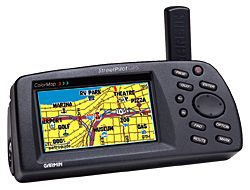
GARMIN's new StreetPilot GPS was the first in the automotive marketplace to offer a comprehensive mapping system that was both portable and affordable. The StreetPilot GPS ColorMap takes up where its sister product left off by boasting a razor-sharp, high-resolution, 16-color display for easy map reading. ColorMap works in an auto, truck, or van.
Designed primarily for the automobile, the ColorMap improves on the StreetPilot's basemap information by adding exit information for the federal interstate highway system that lists available services such as food, lodging, and service stations. It also contains a reference basemap showing Interstate, U.S., and State highways, plus rivers and lakes in the U.S., Canada, and Mexico, with main arterial streets shown in metropolitan areas. Optional MapSource MetroGuide U.S.A. CD-ROMs (and MetroGuide data cards) can be downloaded for street-level map detail and access to business listings and points of interest in your area
The ColorMap features a high-performance twelve parallel channel GPS receiver for quick satellite acquisition and reliable signal reception, whether you're under dense tree cover or surrounded by high-rise skyscrapers. Text and graphics are shown in large type for easy viewing, with a screen brightness adjustment and a night mode that alters the display colors for viewing in dim ambient conditions. The unit also comes with a free cigarette lighter adapter for those times when you don't have to rely on battery power.
(Please note: The ColorMap is a new product and is available only in the Americas at this time. Please watch for future announcements of worldwide coverage and availability.)
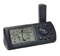
GARMIN's new GPS III Plus offers cartographic capabilities formerly found only in high-end automotive navigation and marine chartplotting units. Simply plug it into a PC and download data from GARMIN's line of MapSource CD ROM's and you instantly get detailed maps.
Whether you're cruising the streets or pounding the waves, GARMIN has the maps you need. Choose the "U.S. Roads and Recreation" CD for city street level detail and even inland marine features such as lake and river shorelines, boat ramp and marina locations. Other CD's give you worldwide coverage of coastlines, including a database of coastal cities, navaids and inland roads.
Even without additional cartography, the basemap in the GPS III Plus will get you where you're going. More than 10,000 new towns have been added to the permanent basemap, as well as airport locations, secondary roads in metro areas and even detailed exit information for the federal interstate highway system, including information about available lodging, food and service stations.
This is the one that I did own
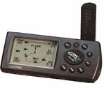 Hot on the heels of the revolutionary GPS II comes GARMIN's high-powered
switchable handheld: the GPS II Plus. Featuring an impressive 12
parallel channel receiver for quick satellite acquisition and enhanced
reception, the GPS II Plus is designed to track any over-the-road journey and offroad
adventure you have in mind. GARMIN's newest compact GPS features a
state-of-the-art two-way screen display for vertical or horizontal
orientation---which makes it easy to go from your vehicle to the
hiking trail.
Hot on the heels of the revolutionary GPS II comes GARMIN's high-powered
switchable handheld: the GPS II Plus. Featuring an impressive 12
parallel channel receiver for quick satellite acquisition and enhanced
reception, the GPS II Plus is designed to track any over-the-road journey and offroad
adventure you have in mind. GARMIN's newest compact GPS features a
state-of-the-art two-way screen display for vertical or horizontal
orientation---which makes it easy to go from your vehicle to the
hiking trail.
With an external antenna for impressive reception, the GPS II Plus also boasts dedicated zoom keys, waypoint symbols, diagonal panning, auto start/stop trip timer, and average and maximum speed recordings. Just four AA batteries will provide upto 24 hours of accurate tracking and precise navigation.
Now the same pinpoint guidance used by pilots the world over is conveniently available to adventurers, regardless of their transportation means: 4x4, ATV, bicycle, motorcycle, snowmobile, boat, or on foot.
The GARMIN GPS II+: A dominating force in GPS--any way you look at it.
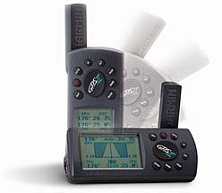 The GPS
II's revolutionary flip-flop screen orientation and a compact, one-handed design, make
this GPS a real
The GPS
II's revolutionary flip-flop screen orientation and a compact, one-handed design, make
this GPS a real
switch-hitter.
Mount it on your boat, ATV, personal watercraft, or bicycle. Take it off for a little land
exploration. Then pop it on the
optional dash mount of your car in the horizontal position for satellite navigation all
the way home.
The GPS II's innovative ways don't stop at versatility. It also sports an impressive list
of nav features - including
user-selectable fields for trip odometer, average and maximum speed, and elapsed and trip
timers, along with compass or
highway steering guidance. There is also moving map plotting with dedicated zoom keys,
room for 250 waypoints and 20
routes, and TracBack breadcrumb navigation. The GPS II is a revolution in GPS - any way
you look at it!
for GPS, Amateur, and anything radio related!
![]()